


Corbeil-Essonnes Marche

jpcccb
User
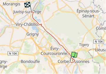

Length
13.7 km

Max alt
52 m

Uphill gradient
129 m
Km-Effort
15.4 km

Min alt
27 m

Downhill gradient
130 m
Boucle
No
Creation date :
2024-11-13 09:23:15.032
Updated on :
2025-02-03 10:34:18.177
3h29
Difficulty : Easy

FREE GPS app for hiking
 SityTrail
IGN / Geographical institutes
SityTrail Plus
The world is yours!
About
Trail On foot of 13.7 km to be discovered at Ile-de-France, Essonne, Corbeil-Essonnes. This trail is proposed by jpcccb.
Description
GR 2
Positioning
Country:
France
Region :
Ile-de-France
Department/Province :
Essonne
Municipality :
Corbeil-Essonnes
Location:
Unknown
Start:(Dec)
Start:(UTM)
461236 ; 5384663 (31U) N.
Comments