


Val croissant comptoir des moutons

alinetpierre
User
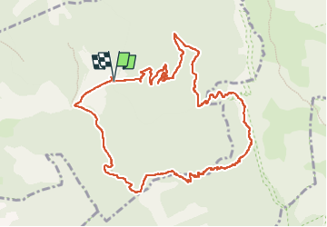

Length
12.6 km

Max alt
1681 m

Uphill gradient
1085 m
Km-Effort
27 km

Min alt
599 m

Downhill gradient
1086 m
Boucle
Yes
Creation date :
2024-11-13 07:17:37.0
Updated on :
2024-11-13 13:35:56.092

FREE GPS app for hiking
 SityTrail
IGN / Geographical institutes
SityTrail Plus
The world is yours!
About
Trail of 12.6 km to be discovered at Auvergne-Rhône-Alpes, Drôme, Die. This trail is proposed by alinetpierre.
Description
Très belle randonnée pour un 13 novembre
Photos


Positioning
Country:
France
Region :
Auvergne-Rhône-Alpes
Department/Province :
Drôme
Municipality :
Die
Location:
Unknown
Start:(Dec)
Start:(UTM)
692585 ; 4957537 (31T) N.
Comments