


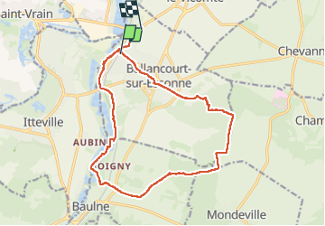
Ballancourt 15km

jeanmarcMasson
User GUIDE

Length
15.5 km

Max alt
151 m

Uphill gradient
152 m
Km-Effort
17.5 km

Min alt
47 m

Downhill gradient
152 m
Boucle
Yes
Creation date :
2024-11-13 09:12:27.396
Updated on :
2024-11-25 16:40:17.639
3h59
Difficulty : Difficult

FREE GPS app for hiking
 SityTrail
IGN / Geographical institutes
SityTrail Plus
The world is yours!
About
Trail Walking of 15.5 km to be discovered at Ile-de-France, Essonne, Ballancourt-sur-Essonne. This trail is proposed by jeanmarcMasson.
Photos

Positioning
Country:
France
Region :
Ile-de-France
Department/Province :
Essonne
Municipality :
Ballancourt-sur-Essonne
Location:
Unknown
Start:(Dec)
Start:(UTM)
453597 ; 5375584 (31U) N.
Comments