


241108 aboen

Julliengamo
User
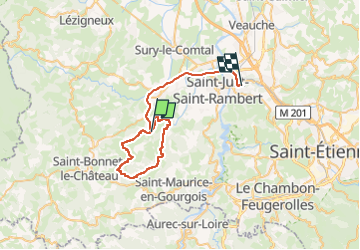

Length
43 km

Max alt
716 m

Uphill gradient
781 m
Km-Effort
53 km

Min alt
360 m

Downhill gradient
893 m
Boucle
No
Creation date :
2024-11-08 13:48:19.806
Updated on :
2024-11-14 15:41:02.597
2h47
Difficulty : Medium

FREE GPS app for hiking
 SityTrail
IGN / Geographical institutes
SityTrail Plus
The world is yours!
About
Trail Mountain bike of 43 km to be discovered at Auvergne-Rhône-Alpes, Loire, Périgneux. This trail is proposed by Julliengamo.
Positioning
Country:
France
Region :
Auvergne-Rhône-Alpes
Department/Province :
Loire
Municipality :
Périgneux
Location:
Unknown
Start:(Dec)
Start:(UTM)
590069 ; 5034654 (31T) N.
Comments