


Tour des Posettes

CABERMAT
User
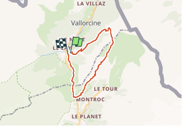

Length
11.4 km

Max alt
2061 m

Uphill gradient
736 m
Km-Effort
21 km

Min alt
1345 m

Downhill gradient
742 m
Boucle
Yes
Creation date :
2024-11-09 08:31:43.648
Updated on :
2024-11-15 12:17:51.136
5h42
Difficulty : Very difficult

FREE GPS app for hiking
 SityTrail
IGN / Geographical institutes
SityTrail Plus
The world is yours!
About
Trail Walking of 11.4 km to be discovered at Auvergne-Rhône-Alpes, Upper Savoy, Vallorcine. This trail is proposed by CABERMAT.
Positioning
Country:
France
Region :
Auvergne-Rhône-Alpes
Department/Province :
Upper Savoy
Municipality :
Vallorcine
Location:
Unknown
Start:(Dec)
Start:(UTM)
339162 ; 5098328 (32T) N.
Comments