


PP et autour

Titinechris
User
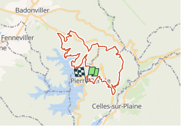

Length
19.3 km

Max alt
564 m

Uphill gradient
630 m
Km-Effort
28 km

Min alt
323 m

Downhill gradient
628 m
Boucle
Yes
Creation date :
2024-11-16 06:44:04.006
Updated on :
2024-11-16 06:45:28.332
3m
Difficulty : Easy

FREE GPS app for hiking
 SityTrail
IGN / Geographical institutes
SityTrail Plus
The world is yours!
About
Trail Trail of 19.3 km to be discovered at Grand Est, Meurthe-et-Moselle, Pierre-Percée. This trail is proposed by Titinechris.
Positioning
Country:
France
Region :
Grand Est
Department/Province :
Meurthe-et-Moselle
Municipality :
Pierre-Percée
Location:
Unknown
Start:(Dec)
Start:(UTM)
346983 ; 5370322 (32U) N.
Comments