


perte de l'Ain

tigrou31
User
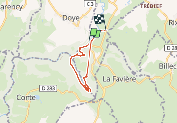

Length
5.2 km

Max alt
758 m

Uphill gradient
139 m
Km-Effort
7.1 km

Min alt
681 m

Downhill gradient
153 m
Boucle
No
Creation date :
2024-11-16 13:30:30.1
Updated on :
2024-11-16 15:19:54.38
1h48
Difficulty : Medium

FREE GPS app for hiking
 SityTrail
IGN / Geographical institutes
SityTrail Plus
The world is yours!
About
Trail Walking of 5.2 km to be discovered at Bourgogne-Franche-Comté, Jura, Doye. This trail is proposed by tigrou31.
Positioning
Country:
France
Region :
Bourgogne-Franche-Comté
Department/Province :
Jura
Municipality :
Doye
Location:
Unknown
Start:(Dec)
Start:(UTM)
272672 ; 5182899 (32T) N.
Comments
j'aime bien cette randonnée !