


puyloubier rbb

Coryphene
User
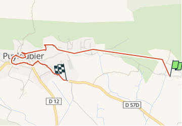

Length
3.7 km

Max alt
380 m

Uphill gradient
61 m
Km-Effort
4.6 km

Min alt
325 m

Downhill gradient
76 m
Boucle
No
Creation date :
2024-11-17 09:00:13.51
Updated on :
2024-11-17 10:56:35.673
1h00
Difficulty : Easy

FREE GPS app for hiking
 SityTrail
IGN / Geographical institutes
SityTrail Plus
The world is yours!
About
Trail Walking of 3.7 km to be discovered at Provence-Alpes-Côte d'Azur, Bouches-du-Rhône, Puyloubier. This trail is proposed by Coryphene.
Positioning
Country:
France
Region :
Provence-Alpes-Côte d'Azur
Department/Province :
Bouches-du-Rhône
Municipality :
Puyloubier
Location:
Unknown
Start:(Dec)
Start:(UTM)
718170 ; 4822477 (31T) N.
Comments