


Moras en valloire l’ecolline

alinetpierre
User
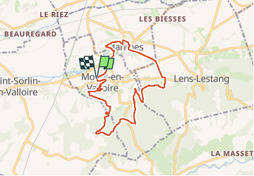

Length
15.7 km

Max alt
419 m

Uphill gradient
337 m
Km-Effort
20 km

Min alt
229 m

Downhill gradient
330 m
Boucle
Yes
Creation date :
2024-11-17 07:36:20.0
Updated on :
2024-11-17 12:04:44.991

FREE GPS app for hiking
 SityTrail
IGN / Geographical institutes
SityTrail Plus
The world is yours!
About
Trail of 15.7 km to be discovered at Auvergne-Rhône-Alpes, Drôme, Moras-en-Valloire. This trail is proposed by alinetpierre.
Description
Rando azur reco jour de la rando école de Moras
Photos


Positioning
Country:
France
Region :
Auvergne-Rhône-Alpes
Department/Province :
Drôme
Municipality :
Moras-en-Valloire
Location:
Unknown
Start:(Dec)
Start:(UTM)
656162 ; 5017258 (31T) N.
Comments