


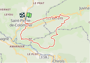
saint pierre de colombier libones aubignas le ranc

raab
User

Length
9.2 km

Max alt
738 m

Uphill gradient
370 m
Km-Effort
14.2 km

Min alt
407 m

Downhill gradient
370 m
Boucle
Yes
Creation date :
2024-11-19 09:36:38.624
Updated on :
2024-11-19 09:38:17.884
3h13
Difficulty : Difficult

FREE GPS app for hiking
 SityTrail
IGN / Geographical institutes
SityTrail Plus
The world is yours!
About
Trail Walking of 9.2 km to be discovered at Auvergne-Rhône-Alpes, Ardèche, Saint-Pierre-de-Colombier. This trail is proposed by raab.
Positioning
Country:
France
Region :
Auvergne-Rhône-Alpes
Department/Province :
Ardèche
Municipality :
Saint-Pierre-de-Colombier
Location:
Unknown
Start:(Dec)
Start:(UTM)
600194 ; 4950918 (31T) N.
Comments