CHAUVIGNÉ-BRAIS 11km JY

COGLAIS3
User
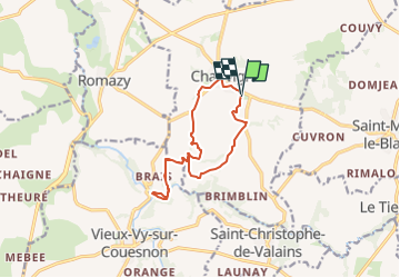

Length
11.1 km

Max alt
95 m

Uphill gradient
144 m
Km-Effort
13 km

Min alt
33 m

Downhill gradient
149 m
Boucle
Yes
Creation date :
2024-11-19 18:05:33.671
Updated on :
2024-11-19 18:10:34.027
0m
Difficulty : Very easy

FREE GPS app for hiking
 SityTrail
IGN / Geographical institutes
SityTrail Plus
The world is yours!
About
Trail Nordic walking of 11.1 km to be discovered at Brittany, Ille-et-Vilaine, Chauvigné. This trail is proposed by COGLAIS3.
Positioning
Country:
France
Region :
Brittany
Department/Province :
Ille-et-Vilaine
Municipality :
Chauvigné
Location:
Unknown
Start:(Dec)
Start:(UTM)
614399 ; 5358874 (30U) N.
Comments