


Col des journaux

audrey54
User
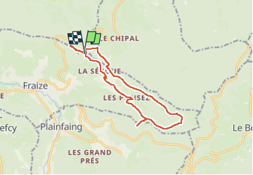

Length
13.8 km

Max alt
1013 m

Uphill gradient
493 m
Km-Effort
20 km

Min alt
696 m

Downhill gradient
502 m
Boucle
Yes
Creation date :
2024-11-20 09:01:34.0
Updated on :
2024-11-20 12:27:40.69
3h25
Difficulty : Difficult

FREE GPS app for hiking
 SityTrail
IGN / Geographical institutes
SityTrail Plus
The world is yours!
About
Trail Walking of 13.8 km to be discovered at Grand Est, Vosges, Mandray. This trail is proposed by audrey54.
Positioning
Country:
France
Region :
Grand Est
Department/Province :
Vosges
Municipality :
Mandray
Location:
Unknown
Start:(Dec)
Start:(UTM)
353323 ; 5340067 (32U) N.
Comments