


ttt

reymond83
User
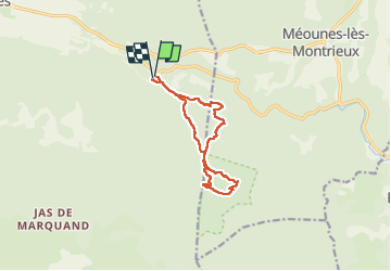

Length
11.4 km

Max alt
538 m

Uphill gradient
329 m
Km-Effort
15.8 km

Min alt
292 m

Downhill gradient
324 m
Boucle
Yes
Creation date :
2024-11-20 08:48:01.16
Updated on :
2024-11-21 22:14:21.508
2h52
Difficulty : Difficult

FREE GPS app for hiking
 SityTrail
IGN / Geographical institutes
SityTrail Plus
The world is yours!
About
Trail Walking of 11.4 km to be discovered at Provence-Alpes-Côte d'Azur, Var, Signes. This trail is proposed by reymond83.
Positioning
Country:
France
Region :
Provence-Alpes-Côte d'Azur
Department/Province :
Var
Municipality :
Signes
Location:
Unknown
Start:(Dec)
Start:(UTM)
736633 ; 4795261 (31T) N.
Comments