


Amicale_Plateau de Larina

d.rognon
User
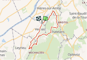

Length
14.1 km

Max alt
420 m

Uphill gradient
456 m
Km-Effort
20 km

Min alt
232 m

Downhill gradient
455 m
Boucle
Yes
Creation date :
2024-11-23 10:44:32.44
Updated on :
2024-11-23 10:46:18.919
4h34
Difficulty : Very difficult

FREE GPS app for hiking
 SityTrail
IGN / Geographical institutes
SityTrail Plus
The world is yours!
About
Trail Walking of 14.1 km to be discovered at Auvergne-Rhône-Alpes, Isère, Vernas. This trail is proposed by d.rognon.
Description
Randonnée du 24/09/24
Positioning
Country:
France
Region :
Auvergne-Rhône-Alpes
Department/Province :
Isère
Municipality :
Vernas
Location:
Unknown
Start:(Dec)
Start:(UTM)
677574 ; 5072311 (31T) N.
Comments