


v et ch version ,2

rouky
User
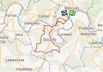

Length
15.8 km

Max alt
303 m

Uphill gradient
515 m
Km-Effort
23 km

Min alt
104 m

Downhill gradient
515 m
Boucle
Yes
Creation date :
2024-11-23 07:30:05.625
Updated on :
2024-11-23 10:51:43.459
3h21
Difficulty : Difficult

FREE GPS app for hiking
 SityTrail
IGN / Geographical institutes
SityTrail Plus
The world is yours!
About
Trail Walking of 15.8 km to be discovered at Occitania, Lot, Mercuès. This trail is proposed by rouky.
Positioning
Country:
France
Region :
Occitania
Department/Province :
Lot
Municipality :
Mercuès
Location:
Unknown
Start:(Dec)
Start:(UTM)
371411 ; 4927215 (31T) N.
Comments