


saint blaise mondragon

losjo
User
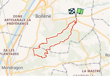

Length
15.7 km

Max alt
191 m

Uphill gradient
357 m
Km-Effort
20 km

Min alt
66 m

Downhill gradient
357 m
Boucle
Yes
Creation date :
2024-11-12 07:28:37.882
Updated on :
2024-11-23 15:20:37.712
5h30
Difficulty : Medium

FREE GPS app for hiking
 SityTrail
IGN / Geographical institutes
SityTrail Plus
The world is yours!
About
Trail Walking of 15.7 km to be discovered at Provence-Alpes-Côte d'Azur, Vaucluse, Bollène. This trail is proposed by losjo.
Description
rando
Positioning
Country:
France
Region :
Provence-Alpes-Côte d'Azur
Department/Province :
Vaucluse
Municipality :
Bollène
Location:
Unknown
Start:(Dec)
Start:(UTM)
642450 ; 4904373 (31T) N.
Comments