


T-A53s-Fontainebleau-Canon-Cuvier

Jack-94
User
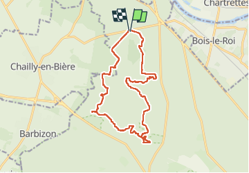

Length
16.8 km

Max alt
152 m

Uphill gradient
239 m
Km-Effort
20 km

Min alt
81 m

Downhill gradient
239 m
Boucle
Yes
Creation date :
2024-11-24 08:36:03.741
Updated on :
2024-11-24 18:28:39.314
6h38
Difficulty : Very difficult

FREE GPS app for hiking
 SityTrail
IGN / Geographical institutes
SityTrail Plus
The world is yours!
About
Trail Walking of 16.8 km to be discovered at Ile-de-France, Seine-et-Marne, Fontainebleau. This trail is proposed by Jack-94.
Positioning
Country:
France
Region :
Ile-de-France
Department/Province :
Seine-et-Marne
Municipality :
Fontainebleau
Location:
Unknown
Start:(Dec)
Start:(UTM)
474315 ; 5369569 (31U) N.
Comments