


Animaux terrestres

yannick-p
User

Length
4.8 km

Max alt
42 m

Uphill gradient
61 m
Km-Effort
5.7 km

Min alt
3 m

Downhill gradient
61 m
Boucle
Yes
Creation date :
2024-11-24 18:37:16.95
Updated on :
2024-11-24 18:39:44.821
2h40
Difficulty : Very easy

FREE GPS app for hiking
 SityTrail
IGN / Geographical institutes
SityTrail Plus
The world is yours!
About
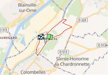
Trail Geocaching of 4.8 km to be discovered at Normandy, Calvados, Ranville. This trail is proposed by yannick-p.
Description
Positioning
Country:
France
Region :
Normandy
Department/Province :
Calvados
Municipality :
Ranville
Location:
Unknown
Start:(Dec)
Start:(UTM)
697360 ; 5454870 (30U) N.
Comments