


241125 Andenne

guy284
User
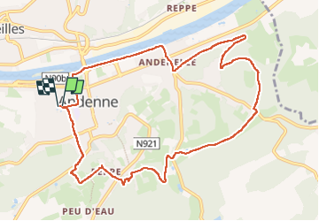

Length
10.3 km

Max alt
201 m

Uphill gradient
264 m
Km-Effort
13.8 km

Min alt
66 m

Downhill gradient
265 m
Boucle
Yes
Creation date :
2024-11-25 13:03:22.857
Updated on :
2024-11-25 15:47:01.346
2h27
Difficulty : Difficult

FREE GPS app for hiking
 SityTrail
IGN / Geographical institutes
SityTrail Plus
The world is yours!
About
Trail Walking of 10.3 km to be discovered at Wallonia, Namur, Andenne. This trail is proposed by guy284.
Positioning
Country:
Belgium
Region :
Wallonia
Department/Province :
Namur
Municipality :
Andenne
Location:
Unknown
Start:(Dec)
Start:(UTM)
648371 ; 5595075 (31U) N.
Comments