


binic étable 11km GR A/R

coglais
User
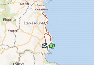

Length
10.8 km

Max alt
78 m

Uphill gradient
280 m
Km-Effort
14.5 km

Min alt
7 m

Downhill gradient
280 m
Boucle
Yes
Creation date :
2024-11-25 18:53:31.676
Updated on :
2024-11-25 18:54:59.463
3h00
Difficulty : Medium

FREE GPS app for hiking
 SityTrail
IGN / Geographical institutes
SityTrail Plus
The world is yours!
About
Trail Nordic walking of 10.8 km to be discovered at Brittany, Côtes-d'Armor, Binic-Étables-sur-Mer. This trail is proposed by coglais.
Positioning
Country:
France
Region :
Brittany
Department/Province :
Côtes-d'Armor
Municipality :
Binic-Étables-sur-Mer
Location:
Binic
Start:(Dec)
Start:(UTM)
513326 ; 5383304 (30U) N.
Comments