


cedat

raab
User
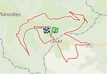

Length
8.5 km

Max alt
489 m

Uphill gradient
224 m
Km-Effort
11.5 km

Min alt
311 m

Downhill gradient
224 m
Boucle
Yes
Creation date :
2024-11-28 09:20:29.445
Updated on :
2024-11-28 11:57:26.897
2h36
Difficulty : Medium

FREE GPS app for hiking
 SityTrail
IGN / Geographical institutes
SityTrail Plus
The world is yours!
About
Trail Walking of 8.5 km to be discovered at Auvergne-Rhône-Alpes, Ardèche, Planzolles. This trail is proposed by raab.
Positioning
Country:
France
Region :
Auvergne-Rhône-Alpes
Department/Province :
Ardèche
Municipality :
Planzolles
Location:
Unknown
Start:(Dec)
Start:(UTM)
592750 ; 4925954 (31T) N.
Comments