


viterne chapelle St anne

ISAGIL
User
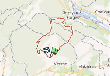

Length
12.9 km

Max alt
373 m

Uphill gradient
257 m
Km-Effort
16.3 km

Min alt
244 m

Downhill gradient
260 m
Boucle
Yes
Creation date :
2024-11-28 12:53:07.051
Updated on :
2024-11-28 15:50:08.167
2h55
Difficulty : Difficult

FREE GPS app for hiking
 SityTrail
IGN / Geographical institutes
SityTrail Plus
The world is yours!
About
Trail Walking of 12.9 km to be discovered at Grand Est, Meurthe-et-Moselle, Viterne. This trail is proposed by ISAGIL.
Positioning
Country:
France
Region :
Grand Est
Department/Province :
Meurthe-et-Moselle
Municipality :
Viterne
Location:
Unknown
Start:(Dec)
Start:(UTM)
280354 ; 5386318 (32U) N.
Comments