


ps casteldiaou

psester
User
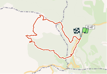

Length
9.5 km

Max alt
556 m

Uphill gradient
394 m
Km-Effort
14.7 km

Min alt
205 m

Downhill gradient
394 m
Boucle
Yes
Creation date :
2024-11-25 07:57:20.988
Updated on :
2024-11-29 08:29:29.746
3h15
Difficulty : Difficult

FREE GPS app for hiking
 SityTrail
IGN / Geographical institutes
SityTrail Plus
The world is yours!
About
Trail Walking of 9.5 km to be discovered at Provence-Alpes-Côte d'Azur, Var, Bagnols-en-Forêt. This trail is proposed by psester.
Description
longue descente un peu pénible à la fin, peut-être la faire à l'envers
Positioning
Country:
France
Region :
Provence-Alpes-Côte d'Azur
Department/Province :
Var
Municipality :
Bagnols-en-Forêt
Location:
Unknown
Start:(Dec)
Start:(UTM)
310502 ; 4822214 (32T) N.
Comments