


boucle de mandray

Titinechris
User
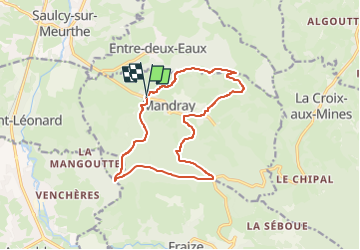

Length
13.6 km

Max alt
737 m

Uphill gradient
569 m
Km-Effort
21 km

Min alt
409 m

Downhill gradient
571 m
Boucle
Yes
Creation date :
2024-11-29 17:33:49.422
Updated on :
2024-11-29 17:33:52.451
4h49
Difficulty : Medium

FREE GPS app for hiking
 SityTrail
IGN / Geographical institutes
SityTrail Plus
The world is yours!
About
Trail Walking of 13.6 km to be discovered at Grand Est, Vosges, Mandray. This trail is proposed by Titinechris.
Positioning
Country:
France
Region :
Grand Est
Department/Province :
Vosges
Municipality :
Mandray
Location:
Unknown
Start:(Dec)
Start:(UTM)
350624 ; 5342768 (32U) N.
Comments