


SDAV2024-12-02_projet

guy284
User
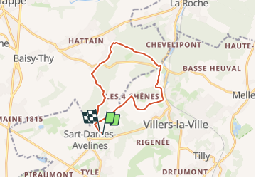

Length
10.6 km

Max alt
165 m

Uphill gradient
170 m
Km-Effort
12.8 km

Min alt
101 m

Downhill gradient
168 m
Boucle
Yes
Creation date :
2024-12-02 10:45:00.909
Updated on :
2024-12-02 10:45:45.049
2h54
Difficulty : Difficult

FREE GPS app for hiking
 SityTrail
IGN / Geographical institutes
SityTrail Plus
The world is yours!
About
Trail Walking of 10.6 km to be discovered at Wallonia, Walloon Brabant, Villers-la-Ville. This trail is proposed by guy284.
Positioning
Country:
Belgium
Region :
Wallonia
Department/Province :
Walloon Brabant
Municipality :
Villers-la-Ville
Location:
Unknown
Start:(Dec)
Start:(UTM)
606144 ; 5603040 (31U) N.
Comments