


Veynes boucle hivernale

rigol05
User
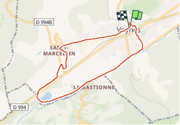

Length
8.7 km

Max alt
847 m

Uphill gradient
91 m
Km-Effort
9.9 km

Min alt
781 m

Downhill gradient
92 m
Boucle
Yes
Creation date :
2024-12-03 12:07:48.503
Updated on :
2025-03-28 17:20:50.722
1h56
Difficulty : Medium

FREE GPS app for hiking
 SityTrail
IGN / Geographical institutes
SityTrail Plus
The world is yours!
About
Trail Walking of 8.7 km to be discovered at Provence-Alpes-Côte d'Azur, Hautes-Alpes, Veynes. This trail is proposed by rigol05.
Positioning
Country:
France
Region :
Provence-Alpes-Côte d'Azur
Department/Province :
Hautes-Alpes
Municipality :
Veynes
Location:
Unknown
Start:(Dec)
Start:(UTM)
724441 ; 4935249 (31T) N.
Comments