


BM Bord de Marne : Nogent-Gournay AR 21km

jeanmarcMasson
User GUIDE
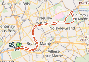

Length
21 km

Max alt
52 m

Uphill gradient
124 m
Km-Effort
23 km

Min alt
32 m

Downhill gradient
127 m
Boucle
Yes
Creation date :
2024-12-04 08:38:19.0
Updated on :
2024-12-05 09:50:42.117
5h10
Difficulty : Very difficult

FREE GPS app for hiking
 SityTrail
IGN / Geographical institutes
SityTrail Plus
The world is yours!
About
Trail Walking of 21 km to be discovered at Ile-de-France, Val-de-Marne, Champigny-sur-Marne. This trail is proposed by jeanmarcMasson.
Photos


Positioning
Country:
France
Region :
Ile-de-France
Department/Province :
Val-de-Marne
Municipality :
Champigny-sur-Marne
Location:
Unknown
Start:(Dec)
Start:(UTM)
462341 ; 5408594 (31U) N.
Comments