


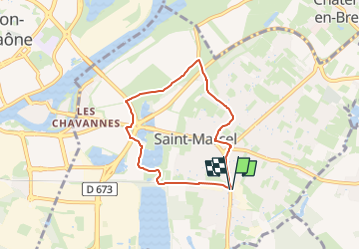
St Marcel , tour des Orlans , les Savettes , retour par le bourg , le cimetière

jeanpaulcheyssac
User

Length
5.8 km

Max alt
181 m

Uphill gradient
31 m
Km-Effort
6.2 km

Min alt
168 m

Downhill gradient
30 m
Boucle
Yes
Creation date :
2024-12-05 11:05:40.961
Updated on :
2025-08-20 15:53:51.421
1h25
Difficulty : Easy

FREE GPS app for hiking
 SityTrail
IGN / Geographical institutes
SityTrail Plus
The world is yours!
About
Trail On foot of 5.8 km to be discovered at Bourgogne-Franche-Comté, Saône-et-Loire, Saint-Marcel. This trail is proposed by jeanpaulcheyssac.
Description
Départ : Depuis le rendez vous du CSC .
Positioning
Country:
France
Region :
Bourgogne-Franche-Comté
Department/Province :
Saône-et-Loire
Municipality :
Saint-Marcel
Location:
Unknown
Start:(Dec)
Start:(UTM)
644597 ; 5181350 (31T) N.
Comments