


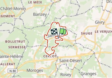
Jambles le mont Avril page 41

grasgilbert
User

Length
11.4 km

Max alt
416 m

Uphill gradient
333 m
Km-Effort
15.8 km

Min alt
254 m

Downhill gradient
340 m
Boucle
Yes
Creation date :
2024-12-05 12:22:31.068
Updated on :
2024-12-05 16:30:14.645
3h00
Difficulty : Medium

FREE GPS app for hiking
 SityTrail
IGN / Geographical institutes
SityTrail Plus
The world is yours!
About
Trail Walking of 11.4 km to be discovered at Bourgogne-Franche-Comté, Saône-et-Loire, Jambles. This trail is proposed by grasgilbert.
Positioning
Country:
France
Region :
Bourgogne-Franche-Comté
Department/Province :
Saône-et-Loire
Municipality :
Jambles
Location:
Unknown
Start:(Dec)
Start:(UTM)
629614 ; 5181080 (31T) N.
Comments