


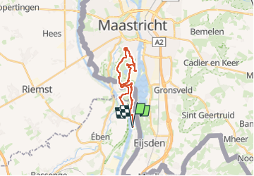
Lannaye Maastricht
© OpenStreetMap contributors


5h57
Difficulty : Easy


Length
18 km
Max alt
163 m
Uphill gradient
405 m
Km-Effort
23 km
Min alt
36 m
Downhill gradient
403 m
Boucle
Yes
Creation date :
2024-12-08 08:56:55.0
Updated on :
2024-12-08 14:56:08.941
5h57
Difficulty : Easy
FREE GPS app for hiking
 SityTrail
IGN / Geographical institutes
SityTrail Plus
The world is yours!
About
Trail Walking of 18 km to be discovered at Wallonia, Liège, Visé. This trail is proposed by gabydeleu@hotmail.com.
Description
Pied
Positioning
Country:
Belgium
Region :
Wallonia
Department/Province :
Liège
Municipality :
Visé
Location:
Unknown
Start:(Dec)
Start:(UTM)
689698 ; 5629834 (31U) N.
Comments