


J5

dansanet
User

Length
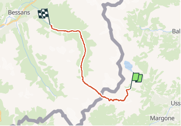
18.4 km
Boucle
No
Creation date :
2024-12-09 07:54:36.245
Updated on :
2024-12-09 07:54:36.245

FREE GPS app for hiking
 SityTrail
IGN / Geographical institutes
SityTrail Plus
The world is yours!
About
Trail of 18.4 km to be discovered at Piemont, Torino, Usseglio. This trail is proposed by dansanet.


Positioning
Country:
Italy
Region :
Piemont
Department/Province :
Torino
Municipality :
Usseglio
Location:
Unknown
Start:(Dec)
Start:(UTM)
354600 ; 5012040 (32T) N.
Comments