


rando vauhallan

Guy Laurent
User
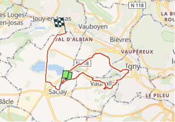

Length
14.7 km

Max alt
159 m

Uphill gradient
157 m
Km-Effort
16.8 km

Min alt
84 m

Downhill gradient
159 m
Boucle
No
Creation date :
2024-11-26 08:13:33.467
Updated on :
2024-12-09 19:25:29.251
2h50
Difficulty : Difficult

FREE GPS app for hiking
 SityTrail
IGN / Geographical institutes
SityTrail Plus
The world is yours!
About
Trail Walking of 14.7 km to be discovered at Ile-de-France, Essonne, Saclay. This trail is proposed by Guy Laurent.
Positioning
Country:
France
Region :
Ile-de-France
Department/Province :
Essonne
Municipality :
Saclay
Location:
Unknown
Start:(Dec)
Start:(UTM)
439285 ; 5398124 (31U) N.
Comments