


balmes de montbrun

raab
User
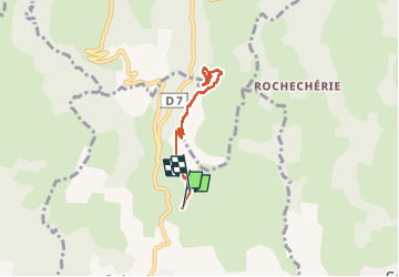

Length
5.9 km

Max alt
605 m

Uphill gradient
246 m
Km-Effort
9.1 km

Min alt
413 m

Downhill gradient
218 m
Boucle
No
Creation date :
2024-12-12 08:44:49.01
Updated on :
2024-12-12 11:18:53.656
2h33
Difficulty : Medium

FREE GPS app for hiking
 SityTrail
IGN / Geographical institutes
SityTrail Plus
The world is yours!
About
Trail Walking of 5.9 km to be discovered at Auvergne-Rhône-Alpes, Ardèche, Saint-Jean-le-Centenier. This trail is proposed by raab.
Positioning
Country:
France
Region :
Auvergne-Rhône-Alpes
Department/Province :
Ardèche
Municipality :
Saint-Jean-le-Centenier
Location:
Unknown
Start:(Dec)
Start:(UTM)
622244 ; 4939711 (31T) N.
Comments