


roche de J'aille (Les Menuires)

CABERMAT
User
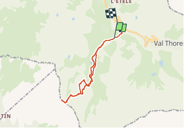

Length
13.7 km

Max alt
2672 m

Uphill gradient
810 m
Km-Effort
25 km

Min alt
1864 m

Downhill gradient
848 m
Boucle
No
Creation date :
2024-12-13 08:13:05.503
Updated on :
2024-12-13 15:10:52.84
6h54
Difficulty : Very easy

FREE GPS app for hiking
 SityTrail
IGN / Geographical institutes
SityTrail Plus
The world is yours!
About
Trail Touring skiing of 13.7 km to be discovered at Auvergne-Rhône-Alpes, Savoy, Les Belleville. This trail is proposed by CABERMAT.

Positioning
Country:
France
Region :
Auvergne-Rhône-Alpes
Department/Province :
Savoy
Municipality :
Les Belleville
Location:
Saint-Martin-de-Belleville
Start:(Dec)
Start:(UTM)
307389 ; 5019213 (32T) N.
Comments