


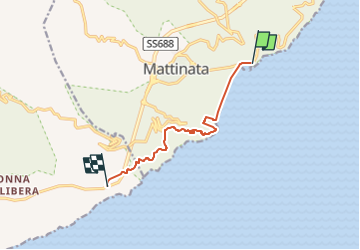
Mattinata - Monte Saraceno 8 km

jeanmarcMasson
User GUIDE

Length
8.2 km

Max alt
229 m

Uphill gradient
253 m
Km-Effort
11.4 km

Min alt
-3 m

Downhill gradient
200 m
Boucle
No
Creation date :
2024-12-13 18:01:57.058
Updated on :
2024-12-13 18:02:59.893
2h36
Difficulty : Medium

FREE GPS app for hiking
 SityTrail
IGN / Geographical institutes
SityTrail Plus
The world is yours!
About
Trail Walking of 8.2 km to be discovered at Apulia, Foggia, Mattinata. This trail is proposed by jeanmarcMasson.
Positioning
Country:
Italy
Region :
Apulia
Department/Province :
Foggia
Municipality :
Mattinata
Location:
Unknown
Start:(Dec)
Start:(UTM)
589662 ; 4618288 (33T) N.
Comments