


benoit

raygautier
User
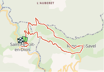

Length
13.3 km

Max alt
1000 m

Uphill gradient
716 m
Km-Effort
23 km

Min alt
348 m

Downhill gradient
729 m
Boucle
Yes
Creation date :
2024-11-24 07:36:32.542
Updated on :
2024-12-14 10:16:53.056
6h07
Difficulty : Very difficult

FREE GPS app for hiking
 SityTrail
IGN / Geographical institutes
SityTrail Plus
The world is yours!
About
Trail Walking of 13.3 km to be discovered at Auvergne-Rhône-Alpes, Drôme, Saint-Benoit-en-Diois. This trail is proposed by raygautier.
Positioning
Country:
France
Region :
Auvergne-Rhône-Alpes
Department/Province :
Drôme
Municipality :
Saint-Benoit-en-Diois
Location:
Unknown
Start:(Dec)
Start:(UTM)
680127 ; 4948061 (31T) N.
Comments