


Lorgues. Flayosc

astein
User
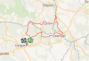

Length
18 km

Max alt
321 m

Uphill gradient
533 m
Km-Effort
25 km

Min alt
149 m

Downhill gradient
534 m
Boucle
Yes
Creation date :
2024-12-15 08:05:27.0
Updated on :
2024-12-21 16:59:13.424
5h42
Difficulty : Very difficult

FREE GPS app for hiking
 SityTrail
IGN / Geographical institutes
SityTrail Plus
The world is yours!
About
Trail Walking of 18 km to be discovered at Provence-Alpes-Côte d'Azur, Var, Lorgues. This trail is proposed by astein.
Positioning
Country:
France
Region :
Provence-Alpes-Côte d'Azur
Department/Province :
Var
Municipality :
Lorgues
Location:
Unknown
Start:(Dec)
Start:(UTM)
287238 ; 4818864 (32T) N.
Comments