


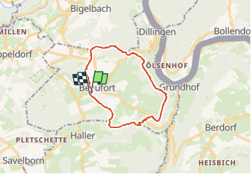
Mullerthal-Sentier-B1

Efr
User

Length
11.7 km

Max alt
394 m

Uphill gradient
247 m
Km-Effort
15 km

Min alt
253 m

Downhill gradient
247 m
Boucle
Yes
Creation date :
2024-12-22 09:50:06.0
Updated on :
2024-12-30 09:19:56.249
3h24
Difficulty : Difficult

FREE GPS app for hiking
 SityTrail
IGN / Geographical institutes
SityTrail Plus
The world is yours!
About
Trail Walking of 11.7 km to be discovered at Unknown, Canton Echternach, Beaufort. This trail is proposed by Efr.
Description
Depart:Beaufort (Luxembourg)
Rue du chateau(parking )
Positioning
Country:
Luxembourg
Region :
Unknown
Department/Province :
Canton Echternach
Municipality :
Beaufort
Location:
Unknown
Start:(Dec)
Start:(UTM)
304900 ; 5523593 (32U) N.
Comments