


Tour de Gavres - 23 déc 2024

morganee
User
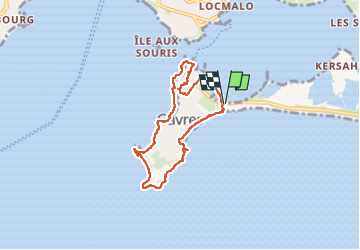

Length
6.4 km

Max alt
10 m

Uphill gradient
26 m
Km-Effort
6.8 km

Min alt
-1 m

Downhill gradient
31 m
Boucle
Yes
Creation date :
2024-12-23 11:32:23.919
Updated on :
2024-12-23 14:13:07.65
2h40
Difficulty : Very easy

FREE GPS app for hiking
 SityTrail
IGN / Geographical institutes
SityTrail Plus
The world is yours!
About
Trail Walking of 6.4 km to be discovered at Brittany, Morbihan, Gâvres. This trail is proposed by morganee.
Positioning
Country:
France
Region :
Brittany
Department/Province :
Morbihan
Municipality :
Gâvres
Location:
Unknown
Start:(Dec)
Start:(UTM)
474024 ; 5282563 (30T) N.
Comments