


De Larmor plage à l'étang du Ter en boucle - 24 déc 2024

morganee
User
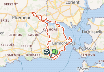

Length
18.8 km

Max alt
35 m

Uphill gradient
194 m
Km-Effort
21 km

Min alt
-2 m

Downhill gradient
194 m
Boucle
Yes
Creation date :
2024-12-24 10:50:22.413
Updated on :
2024-12-24 16:54:20.444
6h02
Difficulty : Easy

FREE GPS app for hiking
 SityTrail
IGN / Geographical institutes
SityTrail Plus
The world is yours!
About
Trail Walking of 18.8 km to be discovered at Brittany, Morbihan, Larmor-Plage. This trail is proposed by morganee.
Positioning
Country:
France
Region :
Brittany
Department/Province :
Morbihan
Municipality :
Larmor-Plage
Location:
Unknown
Start:(Dec)
Start:(UTM)
470600 ; 5283326 (30T) N.
Comments