


autichamp

raygautier
User
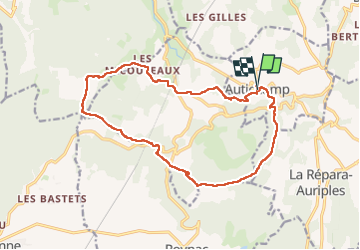

Length
17.1 km

Max alt
481 m

Uphill gradient
477 m
Km-Effort
23 km

Min alt
253 m

Downhill gradient
486 m
Boucle
Yes
Creation date :
2024-12-19 07:22:07.909
Updated on :
2024-12-28 19:58:02.913
6h40
Difficulty : Very difficult

FREE GPS app for hiking
 SityTrail
IGN / Geographical institutes
SityTrail Plus
The world is yours!
About
Trail Walking of 17.1 km to be discovered at Auvergne-Rhône-Alpes, Drôme, Autichamp. This trail is proposed by raygautier.
Positioning
Country:
France
Region :
Auvergne-Rhône-Alpes
Department/Province :
Drôme
Municipality :
Autichamp
Location:
Unknown
Start:(Dec)
Start:(UTM)
655709 ; 4949543 (31T) N.
Comments