


monb

raygautier
User
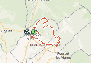

Length
15.8 km

Max alt
631 m

Uphill gradient
617 m
Km-Effort
24 km

Min alt
294 m

Downhill gradient
616 m
Boucle
Yes
Creation date :
2024-12-27 08:02:19.768
Updated on :
2024-12-28 19:58:04.298
7h06
Difficulty : Very difficult

FREE GPS app for hiking
 SityTrail
IGN / Geographical institutes
SityTrail Plus
The world is yours!
About
Trail Walking of 15.8 km to be discovered at Auvergne-Rhône-Alpes, Drôme, Montbrison-sur-Lez. This trail is proposed by raygautier.
Positioning
Country:
France
Region :
Auvergne-Rhône-Alpes
Department/Province :
Drôme
Municipality :
Montbrison-sur-Lez
Location:
Unknown
Start:(Dec)
Start:(UTM)
660506 ; 4922343 (31T) N.
Comments