


plansoie lacour

franquen
User
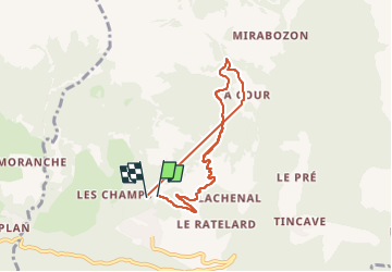

Length
7.2 km

Max alt
1658 m

Uphill gradient
573 m
Km-Effort
14.8 km

Min alt
1236 m

Downhill gradient
577 m
Boucle
Yes
Creation date :
2024-12-29 09:24:29.778
Updated on :
2024-12-29 11:57:03.964
2h31
Difficulty : Very easy

FREE GPS app for hiking
 SityTrail
IGN / Geographical institutes
SityTrail Plus
The world is yours!
About
Trail Touring skiing of 7.2 km to be discovered at Auvergne-Rhône-Alpes, Savoy, Bozel. This trail is proposed by franquen.
Positioning
Country:
France
Region :
Auvergne-Rhône-Alpes
Department/Province :
Savoy
Municipality :
Bozel
Location:
Unknown
Start:(Dec)
Start:(UTM)
315009 ; 5036175 (32T) N.
Comments