


nocturne du nouvel an 2025

stef789
User GUIDE
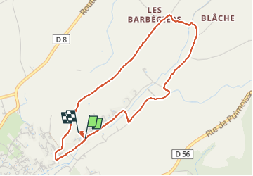

Length
4.8 km

Max alt
613 m

Uphill gradient
78 m
Km-Effort
5.8 km

Min alt
549 m

Downhill gradient
68 m
Boucle
Yes
Creation date :
2024-12-31 22:15:33.396
Updated on :
2024-12-31 23:48:20.781
1h32
Difficulty : Easy

FREE GPS app for hiking
 SityTrail
IGN / Geographical institutes
SityTrail Plus
The world is yours!
About
Trail Walking of 4.8 km to be discovered at Provence-Alpes-Côte d'Azur, Alpes-de-Haute-Provence, Valensole. This trail is proposed by stef789.
Photos


Positioning
Country:
France
Region :
Provence-Alpes-Côte d'Azur
Department/Province :
Alpes-de-Haute-Provence
Municipality :
Valensole
Location:
Unknown
Start:(Dec)
Start:(UTM)
740913 ; 4858761 (31T) N.
Comments