


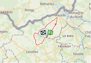
boucle de Lecelles par Maulde

BrassensJC
User

Length
8.4 km

Max alt
42 m

Uphill gradient
47 m
Km-Effort
9 km

Min alt
16 m

Downhill gradient
47 m
Boucle
Yes
Creation date :
2025-01-02 11:56:07.875
Updated on :
2025-01-02 11:57:00.654
2h02
Difficulty : Medium

FREE GPS app for hiking
 SityTrail
IGN / Geographical institutes
SityTrail Plus
The world is yours!
About
Trail Walking of 8.4 km to be discovered at Hauts-de-France, Nord, Lecelles. This trail is proposed by BrassensJC.
Positioning
Country:
France
Region :
Hauts-de-France
Department/Province :
Nord
Municipality :
Lecelles
Location:
Unknown
Start:(Dec)
Start:(UTM)
529477 ; 5592450 (31U) N.
Comments