


74Praz-Rando001-Bourg_Tonnaz_Reon

adye
User
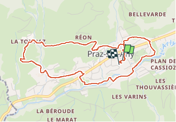

Length
6 km

Max alt
1168 m

Uphill gradient
190 m
Km-Effort
8.6 km

Min alt
1003 m

Downhill gradient
190 m
Boucle
Yes
Creation date :
2025-01-03 10:11:55.405
Updated on :
2025-01-03 13:27:32.394
2h00
Difficulty : Medium

FREE GPS app for hiking
 SityTrail
IGN / Geographical institutes
SityTrail Plus
The world is yours!
About
Trail Walking of 6 km to be discovered at Auvergne-Rhône-Alpes, Upper Savoy, Praz-sur-Arly. This trail is proposed by adye.
Positioning
Country:
France
Region :
Auvergne-Rhône-Alpes
Department/Province :
Upper Savoy
Municipality :
Praz-sur-Arly
Location:
Unknown
Start:(Dec)
Start:(UTM)
311488 ; 5078812 (32T) N.
Comments