


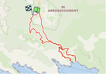
calanque de Sugiton

aurel69
User

Length
13 km

Max alt
243 m

Uphill gradient
473 m
Km-Effort
19.3 km

Min alt
32 m

Downhill gradient
473 m
Boucle
Yes
Creation date :
2025-01-03 08:44:37.517
Updated on :
2025-01-03 14:36:12.115
5h50
Difficulty : Medium

FREE GPS app for hiking
 SityTrail
IGN / Geographical institutes
SityTrail Plus
The world is yours!
About
Trail Walking of 13 km to be discovered at Provence-Alpes-Côte d'Azur, Bouches-du-Rhône, Marseille. This trail is proposed by aurel69.
Description
partie haute et partie basse
Positioning
Country:
France
Region :
Provence-Alpes-Côte d'Azur
Department/Province :
Bouches-du-Rhône
Municipality :
Marseille
Location:
9th Arrondissement
Start:(Dec)
Start:(UTM)
697499 ; 4789317 (31T) N.
Comments