


moncel 9.01.2024

jcb48
User
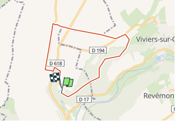

Length
6.8 km

Max alt
346 m

Uphill gradient
118 m
Km-Effort
8.3 km

Min alt
281 m

Downhill gradient
102 m
Boucle
Yes
Creation date :
2025-01-05 08:32:08.254
Updated on :
2025-01-05 08:33:16.902
1h53
Difficulty : Easy

FREE GPS app for hiking
 SityTrail
IGN / Geographical institutes
SityTrail Plus
The world is yours!
About
Trail On foot of 6.8 km to be discovered at Grand Est, Meurthe-et-Moselle, Longuyon. This trail is proposed by jcb48.
Description
marche
Positioning
Country:
France
Region :
Grand Est
Department/Province :
Meurthe-et-Moselle
Municipality :
Longuyon
Location:
Unknown
Start:(Dec)
Start:(UTM)
688226 ; 5481972 (31U) N.
Comments