


J

raygautier
User
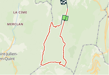

Length
14.2 km

Max alt
1620 m

Uphill gradient
534 m
Km-Effort
22 km

Min alt
1117 m

Downhill gradient
640 m
Boucle
No
Creation date :
2025-01-05 08:34:06.0
Updated on :
2025-01-05 14:26:03.329
5h03
Difficulty : Unknown

FREE GPS app for hiking
 SityTrail
IGN / Geographical institutes
SityTrail Plus
The world is yours!
About
Trail Walking of 14.2 km to be discovered at Auvergne-Rhône-Alpes, Drôme, Vassieux-en-Vercors. This trail is proposed by raygautier.
Positioning
Country:
France
Region :
Auvergne-Rhône-Alpes
Department/Province :
Drôme
Municipality :
Vassieux-en-Vercors
Location:
Unknown
Start:(Dec)
Start:(UTM)
686001 ; 4970395 (31T) N.
Comments