


vassieux

raygautier
User
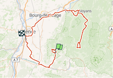

Length
260 km

Max alt
1620 m

Uphill gradient
4116 m
Km-Effort
316 km

Min alt
105 m

Downhill gradient
4457 m
Boucle
No
Creation date :
2025-01-03 07:29:52.119
Updated on :
2025-01-06 08:58:37.084
47h20
Difficulty : Very difficult

FREE GPS app for hiking
 SityTrail
IGN / Geographical institutes
SityTrail Plus
The world is yours!
About
Trail Walking of 260 km to be discovered at Auvergne-Rhône-Alpes, Drôme, Gigors-et-Lozeron. This trail is proposed by raygautier.
Positioning
Country:
France
Region :
Auvergne-Rhône-Alpes
Department/Province :
Drôme
Municipality :
Gigors-et-Lozeron
Location:
Unknown
Start:(Dec)
Start:(UTM)
669237 ; 4962102 (31T) N.
Comments